BROKENHEAD RIVER CANOEING
Your home for paddling on the Brokenhead River

HISTORICAL
IMAGES
These historical images showcase the Brokenhead River from the 1850s to the 2010s. Click each image for details and a complete view and "More Historical Images" at the bottom to see more images.
Do you have old images of the Brokenhead River? Contact here.

R. a la Tete Ouverte (Brokenhead River) on a Plan Showing the Proposed Route from Lake Superior to Red River Settlement. 1859. Cropped. Compiled from the maps of Messrs. Dawson and Napier. Papers Relating to the Exploration of the Country between Lake Superior and the Red River Settlement. S.J. Dawson.

Brokenhead River and Trails to Brokenhead River on Map of the Province of Manitoba. 1873. Cropped. Canada Department of the Secretary of State. Dominion Lands Office.

Dominion Land Survey Map of Township 13, Range 8, East of First Meridian, showing Brokenhead River. (Green Oak - Cromwell - Green Bay Area) 1874. Cropped. Spatial Referencing. Township Diagrams. Manitoba Land Initiative. Her Majesty the Queen in Right of Manitoba, as represented by the Minister of Conservation. All rights reserved.

Brokenhead River on a Map on Mercator's Projection of Part of the N.W. Territory Illustrating the Proposed System of Public Surveys. 1884. Cropped. Canada Department of the Interior. University of Manitoba Archives and Special Collections.

An autumn view of a part of the Brokenhead Ojibway Indian Reserve near the lower end of Lake Winnipeg, Man. (Baaskaandibewiziibing - Brokenhead Ojibway Nation) August 31, 1891. Edward Francis Wilson. Library and Archives Canada, Acc. No. R1433-7.

Brokenhead River at lowest rapid. (Baaskaandibewiziibing - Brokenhead Ojibway Nation) September 29, 1891. Joseph Burr Tyrrell. Geological Survey of Canada. Library and Archives Canada. PA-051459.

1. Threshing Scene at F. McCowan's, Beausejour. 2. Hay Pressing on Jos. Keilbook's Farm, Beausejour. 3. Scene on Brokenhead River near J.D. Campbell's, Beausejour. 4. Hay Barn of E.A. Dugard, Beausejour, wholesale dealer and shipper of pressed hay. 1906. Souvenir of Selkirk and the Rural Municipalities of St. Andrews, St. Clements, Brokenhead and Gimli. Page 23. Selkirk Board of Trade. CIHM 9-90611. University of Alberta.

Brokenhead River and Trail to Brokenhead River on a general plan showing routes for pipelines from Winnipeg River and Shoal Lake to provide drinking water to Winnipeg. 1907. Cropped. Board of Consulting Engineers. Report on a New Water Supply for the City of Winnipeg. Winnipeg Water Supply Commission. Plate IV. University of Manitoba Archives & Special Collections.

A group of men standing in the middle of the frozen Brokenhead River. (near Beausejour) March 22, 1911. The back message states: "Dear Ella, I just rec'd yours and Coras letter. This picture was taken right in the middle of Brokenhead river. Tell Tom he would be crazy to quit and come up here now for there is something wrong all the time. Love. From Frank, x". Peel Postcard 25. Image courtesy of Peel's Prairie Provinces, a digital initiative of the University of Alberta Libraries.

Brokenhead River, Sinnot. Bridge, showing gauge. (St. Ouens) Progress Report of the Manitoba Hydrographic Survey. For the Calendar Years 1912 - 1914. Department of the Interior. Dominion Water Power Branch. Sessional Paper No. 25f. Page 49. 1916. University of Toronto - Robarts Library.

Construction Railway - Brokenhead River Bridge. (City of Winnipeg aqueduct from Shoal Lake) 1914. The Contract Record and Engineering Review. Vol. 28, No. 48. Page 1452. December 2, 1914. University of Toronto - Engineering.

Sun kinks near Brokenhead River in the tracks of the GWWD Railway. (City of Winnipeg Aqueduct from Shoal Lake) 1914 or 1915. Cropped. City of Winnipeg Archives. William Smaill Fonds (A2209 File1). William Smaill Photo Album. Page 8.

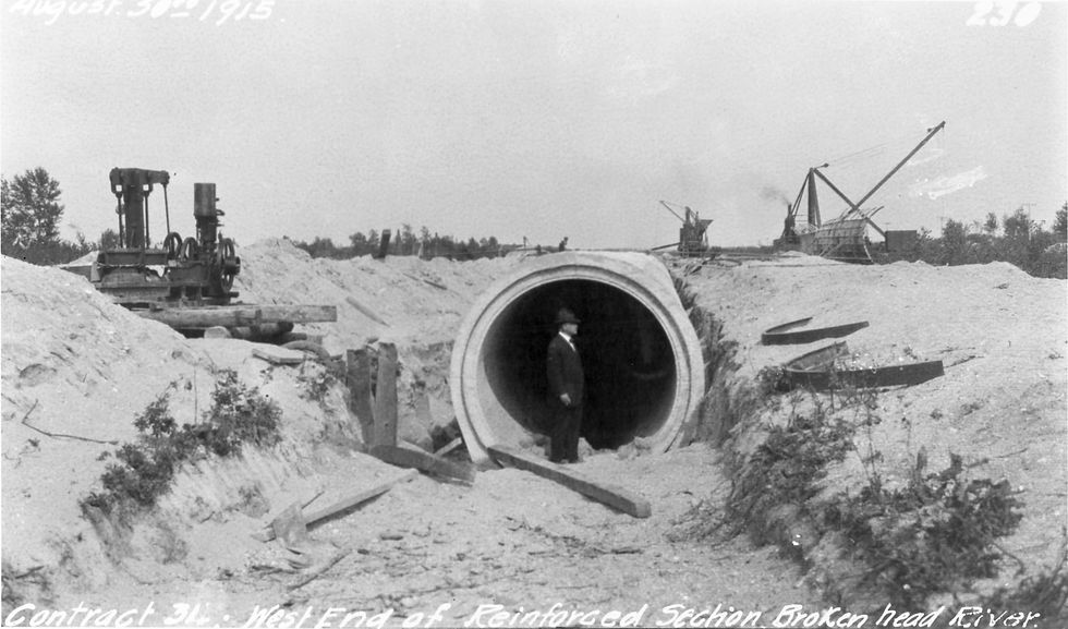
Contract 31 - West End of Reinforced Section, Brokenhead River (City of Winnipeg aqueduct from Shoal Lake). August 30, 1915. City of Winnipeg Archives. Greater Winnipeg Water District Fonds. Photographs (File 1 Image 230).

Brokenhead River - Sinnot - Station and I.P. from below, right bank. Taken by M.S. Madden. (St. Ouens) Progress Report of the Manitoba Hydrometric Survey. For the Calendar Year 1915. Department of the Interior. Dominion Water Power Branch. Water Resources Paper No. 19. No. 25f -1917. 1917. University of Toronto - Robarts Library.

Clean and neat farmstead of the foreign settlement along Brokenhead River, Man. (Polish, Ukrainian, German) 1919. Canada Department of Mines and Technical Surveys. Library and Archives Canada. PA-018144.

Collapse of drainage ditch to Brokenhead River, Man. 15 - 8 East. (Dencross Area) 1919. Canada Department of Mines and Technical Surveys. Library and Archives Canada. PA-018145.

A small river running under a crude wood bridge with a house on the shore. (Brokenhead River) 1921. IBC 001/01-1921B#362. Iwan Boberskyj Collection. Oseredok Ukrainian Cultural and Educational Centre.

R.M St. Clements, Old Bridge at NE 24-15-7E over Brokenhead River. (Highway 12) 1923. Archives of Manitoba. A 0234. Highways Branch Photographs. GR8372. B337-1. ZZ 12-1-2-3.

At a favorite swimming spot on the Brokenhead River. 1930. Courtesy G. Campbell Collection.

Ad for opening day at Dugard's Camp and Parksite on the Brokenhead River. (Sandy - Saulteaux Spritual Centre) 1932. Winnipeg Free Press. May 20, 1932. Page 2. Cropped.